KOREA ADVANCED INSTITUTE OF SCIENCE AND TECHNOLOGY
Convergence Research Center

KAIST 공과대학 융복합연구센터는 AI 융합(AX)분야의 핵심과제인 공간정보, 피지컬AI, 시뮬레이션, 지식융합 등
학제 간 연구 등을 활발하게 추진하고 있습니다.

KOREA ADVANCED INSTITUTE OF SCIENCE AND TECHNOLOGY
Convergence Research Center

KAIST 공과대학 융복합연구센터는 AI 융합(AX)분야의 핵심과제인 공간정보, 피지컬AI, 시뮬레이션, 지식융합 등
학제 간 연구 등을 활발하게 추진하고 있습니다.

KOREA ADVANCED INSTITUTE OF SCIENCE AND TECHNOLOGY
Convergence Research Center

KAIST 공과대학 융복합연구센터는 AI 융합(AX)분야의 핵심과제인 공간정보, 피지컬AI, 시뮬레이션, 지식융합 등
학제 간 연구 등을 활발하게 추진하고 있습니다.

NOTICE

알림마당

KAIST 공과대학 융복합연구센터의 다양한 소식을 전해드립니다.

+
[대전일보] 지방발전의 열쇠, 대동여지도에 있다

2026-08-10

+
[대전일보] 도시안전 AI, 대전에서 길을 찾다

2026-08-07

+
[공간정보 Global Trend 종합정보매거진] VOL.02 Geo Q

2026-01-07

+
[지상대담] " '공간정보 지능화'에 AI 도입은 '필수적' ... 데이터 품질ㆍ전문인력 확보 서둘러야"

2025-11-25

Convergence Research Center
융복합연구센터

KAIST의 IT 연구 분야를 총괄하며 국내외의 기업, 대학과 일괄적 창구로서 IT 분야의 핵심 과제인 ICT, 공간정보, 디지털헬스, 지식융합 등 학제 간 연구 등을 활발하게 추진하고 있습니다.

View
Strategic Business Center
전략사업센터

대전시-KAIST 전략사업 연구센터는 대전시와 KAIST의 협력으로 반도체, 바이오, 우주, 국방 분야에서 혁신적 연구와 전략적 사업 모델을 개발하여 지역 사회와 산업 발전에 기여합니다.

View
Results

연구내용

KAIST 공과대학 융복합연구센터가 도출한 연구내용을 소개합니다.

수행기간 : 2025-06-13 ~ 2025-11-30

과제명 : 데이터지능정보 생성·운영

연구비 : 626,450천원

전담기관 : (사)주소기반산업협회

수행기간 : 2024-07-23 ~ 2025-01-18

과제명 : 주소기반 주차정보 구축 및 주차내비게이션 서비스 모델 실증

연구비 : 380,000천원

중앙행정기관 : 행정안전부

전문기관 : 한국국토정보공사
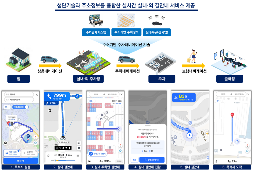

<주소기반 주차내비게이션 개념도>
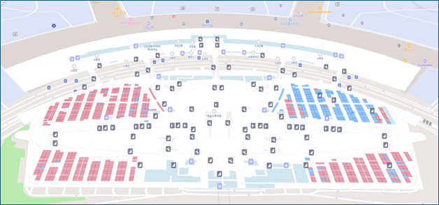
<주소기반 주차내비게이션 인천공항 실증 대상지역>

<인천국제공항 주소기반 주차내비게이션 개발 성과>

Link

수행기간 : 2024-07-01 ~ 2027-12-31

사업명 : SW컴퓨팅산업원천기술개발사업

과제명 : 광역권 도시를 위한 차세대 AI 융합 모빌리티 시뮬레이션 및 예측/활용 기술 개발

연구비 : 6,825,000천원

중앙행정기관 : 과학기술정보통신부

전문기관 : 정보통신기획평가원
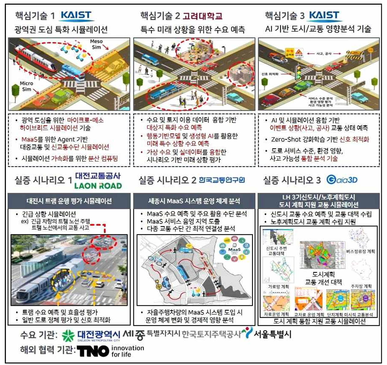
<연구개발 기술 개념도>

수행기간 : 2023-09-08 ~ 2024-04-04

과제명 : 대단위 입체공간 주소기반 실내내비게이션 구현(2023년도)

연구비 : 295,000천원

위탁기관 : 대전광역시
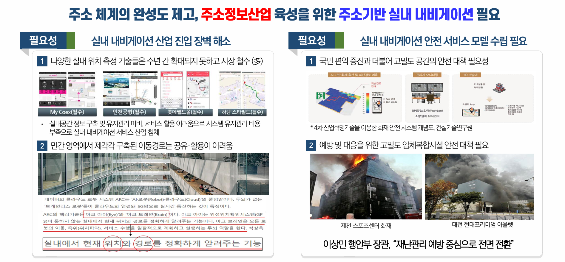
<대단위 입체공간 주소기반 실내내비게이션 사업의 필요성 및 개요>

<행정안전부 고기동 차관(좌)과 KAIST 이채석 교수(우)의 대전시 중앙로 지하상가 실내내비게이션 최종 구현 시범 시현행사 참여 모습>

<대전시 실내내비게이션 시범 관련 MBC 보도자료>

Link

수행기간 : 2022-11-10 ~ 2025-09-30

사업명 : 지자체간협력뉴딜사업

과제명 : 융복합 데이터 활용 실감형 소방안전도시 구축

연구비 : 1,500,000천원

중앙행정기관 : 대전광역시청

전문기관 : 대전광역시
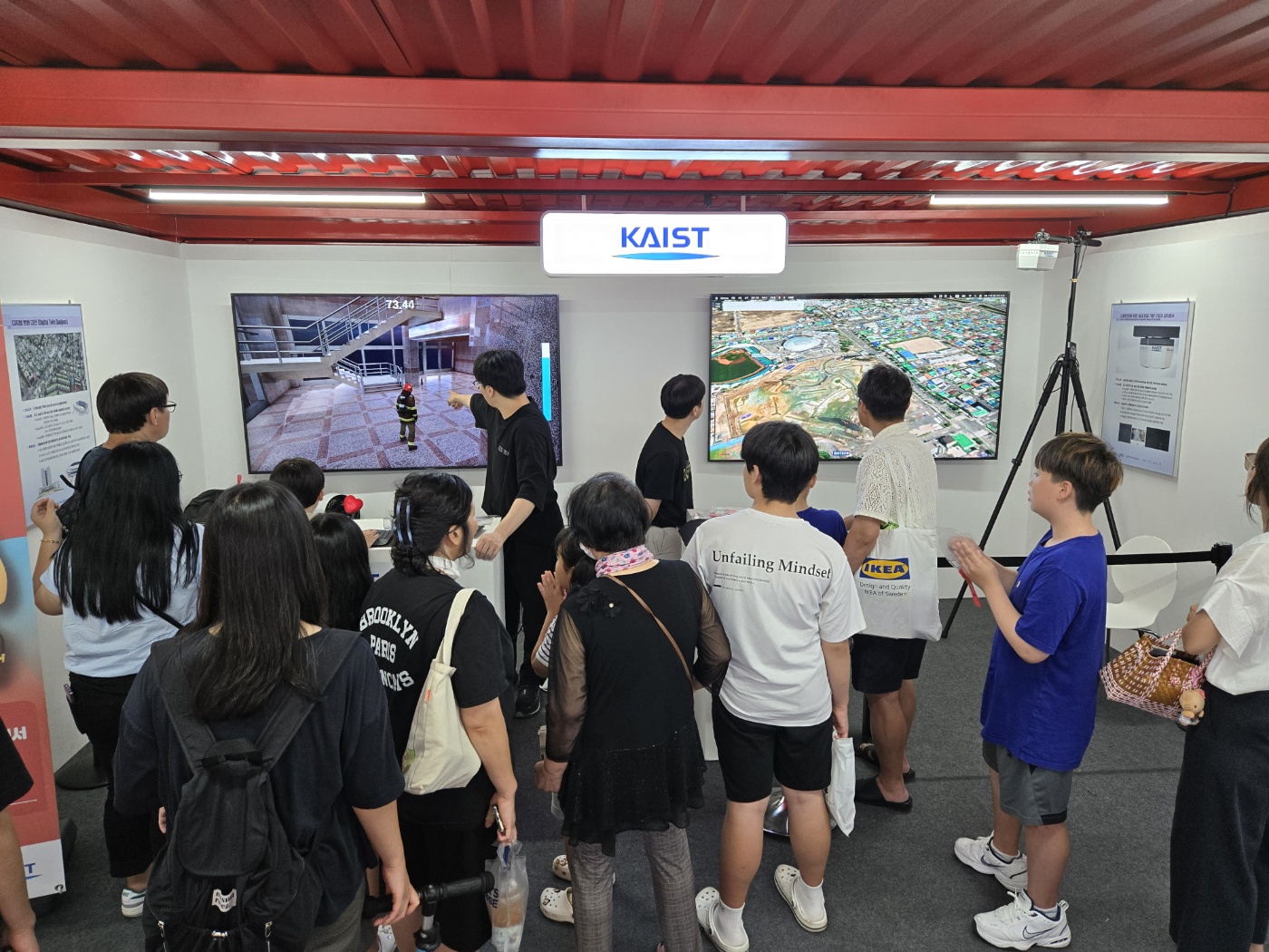
<2024 대전광역시 영시축제 소방안전도시 구축성과 시연 행사 모습>

<mmWave 레이더 센서 기반 화재 상황 사물인식 실험>

<mmWave 레이더 센서 기반 지리참조 클러스터링 기술 연구 및 성과>

Link

수행기간 : 2025-12-26 ~ 2026-04-30

과제명 : 주소기반 데이터지능정보 적용 확대 BIS 위치오류 개선방안 마련

연구비 : 110,000천원

전담기관 : (사)주소기반산업협회

수행기간 : 2025-06-13 ~ 2025-11-30

과제명 : 데이터지능정보 생성·운영

연구비 : 626,450천원

전담기관 : (사)주소기반산업협회

수행기간 : 2025-04-01 ~ 2027-03-31

사업명 : 지역혁신선도기업육성(R&D)- 지역기업 역량강화

과제명 : AI기반 디지털 트윈 기술이 적용된 헬스케어 플랫폼 구축

연구비 : 80,000천원

중앙행정기관 : 중소벤처기업부

전문기관 : 중소기업기술정보진흥원

수행기간 : 2024-11-25 ~ 2025-06-30

사업명 : 산업체사업

과제명 : 차세대 실내지도 데이터 구축 및  표준화 방안연구

연구비 : 186,000천원

위탁기관 : 엘티메트릭(주)

수행기간 : 2024-10-25 ~ 2026-01-31

사업명 : 산업체사업

과제명 : 실내위치측위를 위한 AI장소학습 기술 연구개발

연구비 : 65,000천원

위탁기관 : 파파야(주)

Highlights

연구실적

KAIST 공과대학 융복합연구센터가 달성한 연구실적을 소개합니다.

Accept: 2026-07-01 / Publish: 2026-07-14

Accurate localization of occupants in complex indoor facilities and underground spaces is essential for effective emergency response. However, conventional closed-circuit television (CCTV) and infrared (IR) sensor-based systems suffer from severely degraded detection performance under smoke, reduced illumination, and thermal noise, while also raising privacy concerns. To overcome these limitations, this paper proposes an indoor human detection and geo-referencing system employing distributed 60 GHz millimeter-wave (mmWave) radar sensors that are robust to adverse environmental conditions and inherently privacy-preserving. The proposed system deploys 14 distributed sensors—combining unidirectional (1-Way) and omnidirectional (4-Way) configurations tailored to spatial characteristics—and processes point cloud data in real time through a lightweight middleware architecture. Raw measurements are transformed from spherical to Cartesian coordinates, after which a dimensionality-reduction-based algorithm separates height information, performs two-dimensional density-based clustering (DBSCAN), and subsequently restores height to maximize computational efficiency. A geo-referencing technique incorporating sensor installation positions and orientations precisely converts sensor-relative coordinates to a world coordinate system aligned with building floor plans. The proposed system was validated through a 60-day field demonstration at the Daejeon World Cup Stadium, achieving 99.96% uptime. A controlled geo-referencing evaluation using a publicly available paired radar–skeleton dataset—which provides synchronized mmWave radar point clouds and optical motion capture-based 3D ground-truth coordinates—yielded a mean absolute error (MAE) of 0.59 m against the external skeleton reference after virtual geo-referencing alignment, while an image-based baseline employing a fixed-height assumption exhibited an MAE of 6.04 m, representing an approximately 10.2× improvement. These results demonstrate the practical viability of the proposed framework for privacy-preserving indoor occupant monitoring in complex indoor environments.

Link

학회기간: 2026-07-01 ~ 2026-07-03

본 논문에서는 SHP 기반 실내공간을 정량적으로 분할하고, 격자 중심 연결 방식과 자유 좌표 연결 방식을 이용하여 실내 이동 네트워크를 구축·편집하는 시스템을 제안한다. 제안 시스템은 PyQt5, GeoPandas 및 Shapely를 기반으로 회전 보정 공간분할, 네트워크 생성·분할, 속성 편집 및 SHP 저장 기능을 제공한다. 공공기관 등 13개 실내공간 데이터에 적용하여 동일한 환경에서 공간분할과 네트워크 작성이 가능함을 확인하였다. 제안 시스템은 SHP 기반 실내 네트워크 구축을 지원하고, IndoorGML 구축을 위한 기초 공간자료 작성 도구로 활용할 수 있다.

Accept: 2026-06-10 / Publish: 2026-06-22

Geographic knowledge graphs (GeoKGs) have attracted growing attention for urban digital-twin systems, yet prior work has primarily targeted 3D-visualization efficiency on small scenes rather than district-scale infrastructure analysis. This paper proposes a declarative GeoKG framework that redirects the focus toward analytical capabilities at district scale, with three contributions. First, a declarative rule engine of 7 matching strategies and 18 rules automatically generates 936,739 relationships from 118,231 nodes on Yuseong-gu (Daejeon) and 1,402,275 from 320,863 nodes on Sejong, with 88–100 % independent cross-validation precision for attribute- and proximity-based rules. Second, a physical road-network topology built from TN_RODWAY_NODE/LINK and TL_SPRD_MANAGE delivers 100 % topological coverage of the building–road linkage on both cities, with entrance-aware FRONTS_ROAD anchoring 98.4 % of buildings and the underlying positional quality decomposed quantitatively in the precision-validation section. Third, 16 graph-based analysis functions—including safety assessment, dead-zone identification, and road-closure impact simulation—support evidence-based urban management. End-to-end Neo4j builds complete in ~6 min on Yuseong and ~22 min on Sejong, with sub-2 % rule-engine run-to-run variance across ten independent builds per region; the Sejong/Yuseong engine ratio (3.11  × ) closely tracks the 2.92  × ratio of underlying pair operations, confirming near-linear scaling. Because the rules are declarative JSON specifications independent of any region, the framework is portable to other cities providing equivalent open data. Case studies reveal infrastructure inequality across 45 stable legal-dong of Yuseong (safety-score range 18.5–79.8, 4.3  × best-to-worst gap) and 131 stable legal-dong of Sejong (30.4–80.0, 2.6  × gap), with the gap concentrated in suburban areas with sparse object-address shelter coverage.

Link

Accept: 2026-05-06 / Publish: 2026-05-21

Geographic question answering (QA) requires factually accurate responses grounded in structured spatial knowledge. However, existing approaches based on large language models (LLMs) suffer from factual hallucination, while retrieval-augmented generation (RAG) lacks structural reasoning capabilities. We propose GNLM (Graph-Native Language Model), a novel architecture that restructures the traditional LLM pipeline by performing all reasoning through knowledge graph traversal and restricting the role of LLMs to natural language generation. The knowledge graph is constructed exclusively from government public data sources (building registry, road name addresses) and expert-curated domain knowledge, ensuring factual reliability without LLM-generated content. GNLM introduces four key contributions: 1) a Graph-First, LLM-Last architecture with fact validation that structurally prevents fabrication (all observed errors stem from knowledge gaps, not false generation); 2) an extended Resource Description Framework (RDF) triple attribute model that represents entity properties as independent graph nodes connected by semantic edges, enabling property-level querying and meta-reasoning; 3) coordinate-free spatial reasoning that leverages the Korean road numbering standard (20 m interval, k=10  m per unit) for proximity ranking without Global Positioning System (GPS) coordinates; and 4) a 14-strategy reasoning router that classifies queries into specialized graph traversal algorithms. Evaluated on a real-world dataset of Daejeon, South Korea ( 58,882 nodes, 80,088 edges from 58,408 buildings and 711 roads), GNLM achieves 88.4% accuracy on 250 diverse queries with a hallucination rate (HR) of only 5.7% on 35 fact-verification queries, compared to 60.0% for pure LLM, 25.7% for Dense RAG, and 17.1% for GraphRAG—demonstrating a consistent improvement as structural grounding increases. Cross-model validation with llama3.1:8b confirms LLM-agnostic generalizability. Multi-region validation on Sejong City ( 17,008 buildings) with identical methodology confirms cross-region generalizability (Yuseong-gu avg ρ=0.976 , Sejong avg ρ=0.973 , both over 10 roads). Road-number-based proximity ranking achieves Spearman ρ=0.9878 and Precision@ 10=96.0% against GPS ground truth, with short-range (<500 m) Mean Absolute Error (MAE) of only 31.9 m, demonstrating that structured address numbers alone can effectively preserve spatial ordering without any coordinate data. Cross-road queries, supported via a graph-native intersection topology with 34 annotated intersections, achieve a 90% resolution rate with Spearman ρ=0.701 —substantially lower than same-road accuracy, indicating a current practical limitation that motivates the multi-hop and automated intersection-detection extensions.

Link

Accept: 2026-04-22 / Publish: 2026-05-06

Large language models (LLMs) have demonstrated considerable capability in spatial reasoning, yet prior work has focused primarily on diagnosing the limits of LLM spatial cognition rather than identifying which input representations improve performance. This study addresses a complementary question: how should spatial information be structured to support LLM-based spatial reasoning? We propose a five-level spatial abstraction hierarchy—from raw coordinates (L1) through semantic labels (L2), natural-language relations (L3a), domain-specific rules (L3b), to pre-computed distance tables (L4)—and evaluate its effects on four task families: category-filtered retrieval (H1), relative position reasoning (H2), rule-constrained inference (H3), and distance comparison (H4). Experiments span controlled synthetic urban scenes (8, 12, and 16 objects), four real-world geographic information system (GIS) scenes derived from OpenStreetMap (Daejeon, South Korea), four open-source models, and two commercial models (GPT-5.2, Claude Sonnet 4.5), with paired bootstrap confidence intervals, McNemar tests, and five-seed replication. The results comprise one design precondition validation and three principal findings. As a precondition, semantic labels are confirmed as a structural prerequisite for category-based tasks—an expected but empirically verified requirement ( p<0.001 ). The three findings are: 1) explicit natural-language relation sentences interfere with coordinate-based position reasoning ( 19.7±7.0%p ), with transition analysis confirming that 83% of answer flips are correct-to-incorrect and conflict-trust experiments revealing a wrong-follow rate of 25.6%, although this interference is model- and context-dependent; 2) domain-specific rule injection provides conditional benefit modulated by scene complexity ( +18.3±4.9%p , with substantial scene-level variation); and 3) distance tables yield gains inversely related to the model’s numerical computation ability (+ 2.7 to +84.1%p ). These results establish that effective AI-ready spatial representations should be optimized for task relevance and model fit—prioritizing semantic grounding and task-contingent augmentation over information density.

Link

특허출원일 : 2024-11-19

- 발명의 명칭 : 객체 탐지 시스템 및 그 방법

- 출원일자 : 2024.11.19

- 출원번호 : 10-2024-0164716

특허출원일 : 2024-05-31

- 발명의 명칭 : 최적 시계열 예측 모델 결정 장치 및 그 동작 방법

- 출원일자 : 2024.05.31

- 출원번호 : 10-2024-0071837

특허출원일 : 2023-08-04

- 발명의 명칭 : 디지털트윈용 실내공간 처리 장치 및 그 방법

- 출원일자 : 2023.08.04

- 출원번호 : 10-2023-0102091


특허출원일 : 2023-07-06

- 발명의 명칭 : 사용자 건강자료 기반의 헬스모니터링 및 헬스케어콘텐츠 제공 장치 및 방법

- 출원일자 : 2023.07.06

- 출원번호 : 10-2023-0087480

특허출원일 : 2022-12-28

- 발명의 명칭 : 사용자의 맥파 기반 건강 점수를 산출하는 장치 및 그 방법

- 출원일자 : 2022.12.28

- 출원번호 : 10-2022-0187010